LCZ Factsheet
Saudi Arabia, Kingdom of - Riyadh District
User Information
- Author: Amjad Azmeer
- Continent: Asia
- Country: Saudi Arabia, Kingdom of
- City: Riyadh District
- Reference:
- Remarks:
- Representative date: 2024-01-23
- Submission date: 2024-08-18 09:21
- Software version: 2.2.0
- ID: 6ead09e6a4cdf648517466af1aac64a245e502a3

See this file for more information on:
- Available LCZ classes
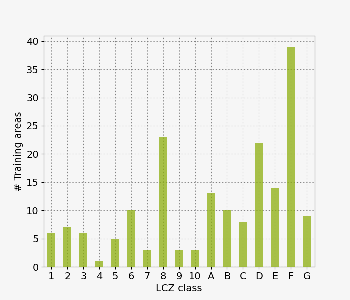
- Number of training areas per LCZ class
- Average / Total surface area (km2) per LCZ class
- Average perimeter (km) per LCZ class
- Average shape per LCZ class
- Average number of vertices per LCZ class
LCZ map & Accuracy
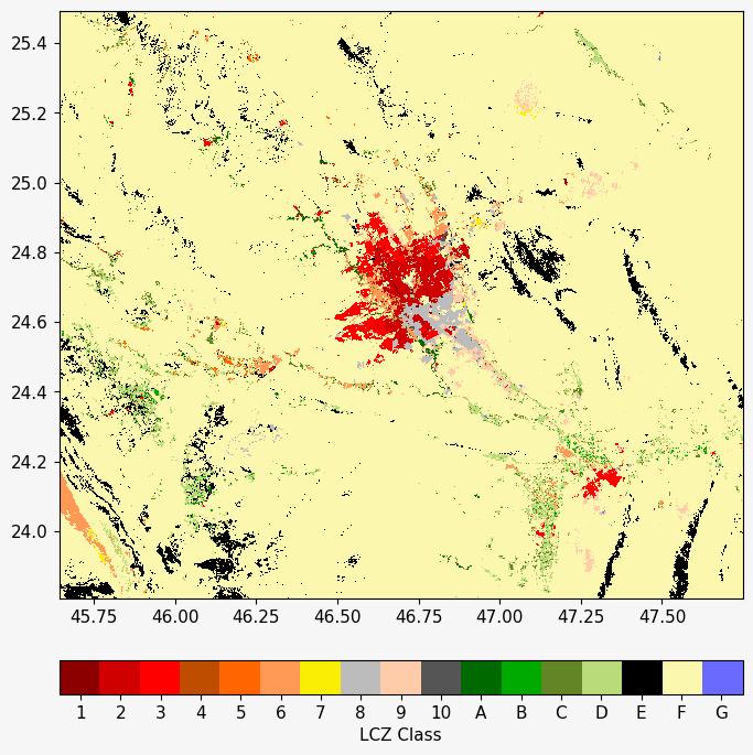
The final filtered LCZ map is produced using all training areas and input features. Corresponding overall accuracies are:
- OA: 0.59
- OAu: 0.56
- OAbu: 0.88
- OAw: 0.88

Terms of Service
All data are distributed under the CC BY-NC-SA 4.0 license. In particular, permission is hereby granted, free of charge, to any person obtaining a copy of this data and associated documentation files, to copy and redistribute the material in any medium or format, and to remix, transform, and build upon the material for non-commercial use only, all subject to the following:
- Understand that these data are created by crowdsourcing and machine learning and will - by design - contain errors. It comes as is without any warranty. We do not guarantee the quality and reliability of this dataset and assume no responsibility whatsoever for any direct or indirect damage and loss caused by use of this dataset or damages for users due to changing, deleting or terminating the provision of this dataset.
- The provided copyright and permission notice shall be included in all copies or substantial portions of the data. If you remix, transform, or build upon the material, you must distribute your contributions under the same license as the original.
- You must give appropriate credit, provide a link to the license, and indicate if changes were made. You may do so in any reasonable manner, but not in any way that suggests the licensor endorses you or your use.
- The authors are acknowledged appropriately and changes must be indicated. The persons referred to as authors developed the original training dataset.
Attribution
Please use the following citation when using the LCZ Generator:
- Demuzere, M., Kittner, J., Bechtel, B. (2021). LCZ Generator: a web application to create Local Climate Zone maps. Frontiers in Environmental Science 9:637455. https://doi.org/10.3389/fenvs.2021.637455
In case you use training area data of one or more cities, we suggest to add the following statement to the acknowledgements:
- We acknowledge all WUDAPT contributors for providing the training areas for our city/cities of interest.
Alternatively, you can also explicitly cite this training data by using the following reference:
- Azmeer, Amjad (2024). WUDAPT Level 0 training data for Riyadh District (Saudi Arabia, Kingdom of), submitted to the LCZ Generator. This dataset is licensed under CC BY-NC-SA, and more information is available at https://lcz-generator.rub.de/factsheets/ 6ead09e6a4cdf648517466af1aac64a245e502a3/6ead09e6a4cdf648517466af1aac64a245e502a3_factsheet.html
All required Local Climate Zone context and in-depth methodological information is provided in the following papers. Please cite where appropriate.
- Stewart, I. D., & Oke, T. R. (2012). Local Climate Zones for Urban Temperature Studies. Bulletin of the American Meteorological Society, 93(12), 1879-1900. https://doi.org/10.1175/BAMS-D-11-00019.1
- Bechtel, B., & Daneke, C. (2012). Classification of local climate zones based on multiple earth observation data. IEEE Journal of Selected Topics in Applied Earth Observations and Remote Sensing, 5(4), 1191-1202. https://doi.org/10.1109/JSTARS.2012.2189873
- Bechtel, B., Alexander, P., Böhner, J., Ching, J., Conrad, O., Feddema, J., … Stewart, I. (2015). Mapping Local Climate Zones for a Worldwide Database of the Form and Function of Cities. ISPRS International Journal of Geo-Information, 4(1), 199-219. https://doi.org/10.3390/ijgi4010199
- Gorelick, N., Hancher, M., Dixon, M., Ilyushchenko, S., Thau, D., & Moore, R. (2017). Google Earth Engine: Planetary-scale geospatial analysis for everyone. Remote sensing of Environment, 202, 18-27. https://doi.org/10.1016/j.rse.2017.06.031
- Bechtel, B., Demuzere, M., Sismanidis, P., Fenner, D., Brousse, O., Beck, C., … Verdonck, M.-L. (2017). Quality of Crowdsourced Data on Urban Morphology—The Human Influence Experiment (HUMINEX). Urban Science, 1(2), 15. https://doi.org/10.3390/urbansci1020015
- Ching, J., Mills, G., Bechtel, B., See, L., Feddema, J., Wang, X., … Theeuwes, N. (2018). WUDAPT: An Urban Weather, Climate, and Environmental Modeling Infrastructure for the Anthropocene. Bulletin of the American Meteorological Society, 99(9), 1907-1924. https://doi.org/10.1175/BAMS-D-16-0236.1
- Bechtel, B., Alexander, P. J., Beck, C., Böhner, J., Brousse, O., Ching, J., … Xu, Y. (2019). Generating WUDAPT Level 0 data - Current status of production and evaluation. Urban Climate, 27, 24-45. https://doi.org/10.1016/j.uclim.2018.10.001
- Demuzere, M., Bechtel, B., & Mills, G. (2019). Global transferability of local climate zone models. Urban Climate, 27, 46-63. https://doi.org/10.1016/j.uclim.2018.11.001
- Demuzere, M., Bechtel, B., Middel, A., & Mills, G. (2019). Mapping Europe into local climate zones. PLOS ONE, 14(4), e0214474. https://doi.org/10.1371/journal.pone.0214474
- Bechtel, B., Demuzere, M., & Stewart, I. D. (2020). A Weighted Accuracy Measure for Land Cover Mapping: Comment on Johnson et al. Local Climate Zone (LCZ) Map Accuracy Assessments Should Account for Land Cover Physical Characteristics that Affect the Local Thermal Environment. Remote Sens. 2019, 11, 2420. Remote Sensing, 12(11), 1769. https://doi.org/10.3390/rs12111769
- Demuzere, M., Hankey, S., Mills, G., Zhang, W., Lu, T., & Bechtel, B. (2020). Combining expert and crowd-sourced training data to map urban form and functions for the continental US. Nature Scientific Data. https://doi.org/10.1038/s41597-020-00605-z
